
GalleryView all (3)

About Us
A Surveyor Is A Professional Person With Academic Qualifications
- General Info
Croft Surveying and Mapping is a proudly local surveying and mapping business in the New England region.
Michael has had extensive spatial experience in land and engineering surveying, terrain modeling, design and analysis. He holds the qualifications of Registered Land Surveyor, Bachelor of Surveying and Graduate Diploma in Geomatics (GIS), and has undertaken studies in marketing management.
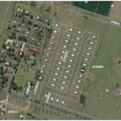
Land Surveying:Property Subdivision Contour and Detail Planning Easements Strata SubdivisionEngineering Construction:Building Set Out General Construction ProjectsGeographical Information Systems:Site Analysis Local Environmental PlanningMapping - High Resolution Aerial Photos: High Resolution Mapping is available in both wall poster and electronic format, and can be overlaid with:Proposed Buildings Paddocks Contours Water (dams, troughs, tanks, water pipes) Additional requirements
- Email Business
- Payment method
- cheque, cash
- ABN
- 87 562 796 802
- Service Notes
- Open Monday to Friday
- Other Links
- Category
- Commercial
- Yes
- Keywords
- Terrain Modelling, Mapping, Technical Expertise, Surveyors, Analysis, Croft Surveying & Mapping, Design, Detail Surveys, Engineering Surveying, GIS
FAQs
How can I contact you?
You can contact us through: Tel: 02 6772 1077 Email: [email protected] Website: http://www.croftsurveying.com/.
What is a Surveyor?
A Surveyor is a professional person with academic qualifications, technical expertise, interpretative ability and management skills to practice the discipline of surveying for the benefit of society.
What is GIS?
Geographical Information System is a collection of computer hardware, software, and geographic data for capturing, managing, analysing, and displaying all forms of geographically referenced information.