
Cross Solutions
34 Years
in Business
12 Years with
Yellow Pages
We will always strive for service excellence and embrace continuous improvement to achieve better outcomes for our clients.
We are a strong established consultancy of more than 20 years standing with well trained, experienced and committed staff that will assist you in delivering your projects. We are concerned with health and safety at work and the protection of the environment & we provide employees with safe working conditions, procedures and practices.
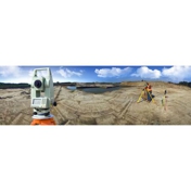
Engineering Surveys Mine Surveys Property Development Geographic Information System Drafting & Visualisation Mapping & Scanning Hydrographic Survey Construction Set Out
Do you offer any employment opportunities at Cross Surveyors?
We are always looking for skilled and motivated people to join our team. Generally we employ Surveyors, Spatial Scientists, Survey Technician's, Drafting and Visualisation Specialists. If you have a positive attitude and would like to tell us a bit more about where you've been, what you've done and who you are, then contact us today!
Do you have discounts available?
We have a few discount options available to clients. Our Prompt payment discount gives clients a 2% discount if they pay within 10 days of the invoice date, the Cumulative quantity discount is a reward for repeat customers who may need our services on a regular basis and the Referral discount is for customers who refer our services to a colleague or business associate & receive a 2% discount on their next invoice.
Do you offer Quick Plans?
Yes, we can provide aerial photography with a digital terrian model and contours at a moments notice. This includes Strategic Planning, Preliminary Quantities, Preliminary Design, Project Presentation & Project Visualistaion. It's quick & inexpensive and no survey is required.