
CalCo Surveyors Pty Ltd
40 Years
in Business
14 Years with
Yellow Pages
CalCo Surveyors Pty Ltd is consulting Surveyors operating in the Gloucester, Great Lakes & Walcha regions since 1986.
CalCo Surveyors Pty Ltd commenced in July 2006 and operates in the Mid North Coast and Upper Hunter Regions of NSW as a renamed version of Calver de Witt and Taylor Pty Ltd.
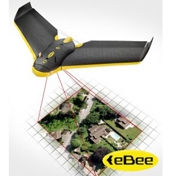
CalCo Surveyors Pty Ltd is now a CASA approved Owner/Operator (CASA.UOC.0120) for the latest drone technology which incorporates eMotion and Post Flight Terra 3D software. This enables aerial surveys to be conducted accurately, safely, and rapidly. It can capture images with a ground resolution of 3 to 10cm per pixel. Area up to 10km can be mapped in a single flight depending on image resolution and flight altitude.
CalCo Surveyors Pty Ltd provide the full range of surveying services to residential, industrial, commercial, civil and mining projects and specialise in rural and residential subdivision development. The practice has always placed emphasis on quality and client satisfaction.
We Are Currently Involved In-UAV (Unmanned Aerial Vehicle) Surveys Small To Large Subdivisions Including Strata Developments Mining Operations In Gloucester And Wards River Area GPS Control Networks Computed Aided Drafting (Civil cad) Council Road Re-Alignment Surveys Council Road And Infrastructure Designs Boundary Re-Marking House And Shed Set Outs Creation Of Easements Call us to know more.
What is the range of surveying equipment you have?
The practice is equipped with a range of surveying equipment including a fully autonomous remotely-piloted UAV (Unmanned Aerial Vehicle – eBee), Trimble RTK GPS, GNSS system and Trimble fully robotic S8 Total Station.
How far can you travel?
We can travel to you if you're in the Hunter Valley region and the Mid North Coast. Don't hesitate to call to find out if we can help you!
Whom do you offer your services to?
We offer our services to residential, industrial, commercial, civil, mining projects, rural and rural residential subdivisions.
Do you use drone technology in your work?
Yes, CalCo Surveyors Pty Ltd is now a CASA approved Owner/Operator (CASA.UOC.0120) for the latest drone technology which incorporates eMotion and Post Flight Terra 3D software. This enables aerial surveys to be conducted accurately, safely, and rapidly.
Do you use computer-aided design systems for surveying and engineering calculations?
Yes, we use computer-aided design systems for surveying and engineering calculations.