
Geelong Survey Solutions
20 Years
in Business
We specialise in feature & level surveys, ResCode surveys and building set outs. Fast turnaround and professional service.
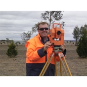
Geelong Survey Solutions, based in Gnarwarre, Geelong in Victoria, is a locally owned LAND SURVEYORS with over 20 years of industry experience. ~Led by Craig Vanderpol, the company specializes in feature and level surveys, ResCode and streetscape surveys, building set outs, vegetation control, and monitoring surveys. ~ Experience our quick quotes, excellent personal service and fast turnaround. ~All areas in Victoria ~ For Architects, Draftsman and Building Designers ... Geelong Survey Solutions specialise in projects for building designers, architects, draftsman, engineers and owner builders. Your clients will appreciate the competitive rates and fast turnaround. And our guaranteed accuracy and more detail provides for better design. Whether a new build, extension or renovation we can provide a quote to suit your requirements. Specialised Quotes - ✔ Quote for Only What You Need – helping your clients save money by paying only for the services they require. ✔ Fast 24-Hour Quotes – prompt pricing to keep your projects moving. ✔ Better Information, Better Design – accurate, detailed information leads to better-informed design decisions. ~ Give us a call and tell us about your project and we will see how we can assist (03) 5265 6000 or email [email protected]
We specialise in:Vacant land surveys ResCode feature surveys Streetscape surveys Building set outs Engineering set outs AHD connection surveys (flood level)
We can provide:Fast turnaround Competitive price Accuracy with the latest computers calibrated and tested equipment Peace of mind with a fully qualified surveyor with over 15 years of experience Availability & personal service
We cover all areas of Geelong & surrounding areas within 100km. This covers most of Melbourne, down the Great Ocean Road to Lorne, Ballarat, Colac, Bacchus Marsh, Werribee, and Bellarine Peninsula. We also travel to other areas in Victoria with an extra travel charge, however, this can be just as competitive with local surveyors.
What else do you provide?
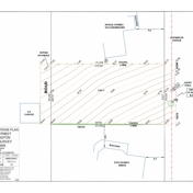
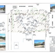
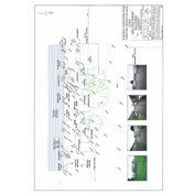
A hard copy (A3 colour copy) of your plan to scale. Photos of the site for views and aspects, shadows and overlooked spaces. Barwon Water ProFIS plan site report page which advises of conditions of the site including access, fencing heights, and extra details that can assist your building with planning their project (PDF plan).
What do we get for our money?
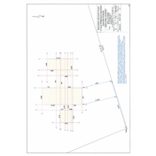
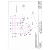
For feature & level surveys field party attends on site and records measurements and locations etc. Our draftsperson drafts email to you and architect with AutoCAD file, pdf and photos post A3 colour hard copy plan, site report, invoice and also files on disk can be provided. For building set outs field party attends on site to set out offsets of external wall lines email set out plan showing marks placed post hard copy plan with invoice.
How do I contact you?
Give us a call on (03) 5265 6000 or send an email to [email protected]. Tell us what type of survey you are after and give your site address and contact details. We will then send you a quick quote and you can decide if you wish to proceed. If acceptable, sign and return a quote to go ahead with a copy of the plans or plan of subdivision or fill out the contact form at https://www.geelongsurveysolutions.com.au/contact.html.
What do I need to provide?
Site address, type of survey required and the whole property required or just the house site area (provide a sketch or stakes on site). Details: name for invoice, postal address, phone number, email address, copy of title plan, advise any access requirements.
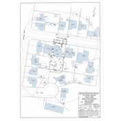
What is a streetscape survey?
This new level of the ResCode survey has been requested by the council when a planning permit is required or for subdivisions. The streetscape survey includes the outline of neighbouring buildings, a description and street setback measurement in a 50 metre radius from the subject site.
Do you do re-establishment of title boundaries?
Unfortunately, no. We are restricted from doing this cadastral licensed surveyor work ourselves. However, if your survey includes a ResCode/feature/building set out the survey, we can sub-contract a licensed surveyor and organise the re-establishment of title boundaries together with the survey as one project for you. This can often be a more efficient process. Send us an email for a quote.
Do you do subdivisions?
Unfortunately, no. We specialise in more land and engineering surveying (not cadastral surveying). So, we can focus on smaller jobs, efficient turnaround and more flexibility to fit in urgent jobs for builders and clients. You will need a licensed surveyor to do the subdivision part of your project. However, we can often fast track your subdivision process for you by getting the feature/ResCode/streetscape survey started earlier and forward this information on to any licensed surveyor.
What is the turnaround?
We endeavour to provide a completed survey one week from receiving go ahead. We attend within the week and provide a plan shortly thereafter by email and post.
How long does a quote take?
We endeavour to reply to your quote enquiry within 24 hours because we want your work. Send us an email with the details of the survey you require, your contact name, site address and we will email you back with our easy to understand simple quote form. If acceptable, all you have to do to proceed, is check and sign the quote and return to us giving authority to proceed. Have a look at our example surveys online www.geelongsurveysolutions.com.au to see the types you require.
Do you provide the AutoCAD drawing file?
Yes, we email you the AutoCAD drawing file which you can forward to architects/designers/builders. They can use this accurately to scale information and overlay plans on top of the site.